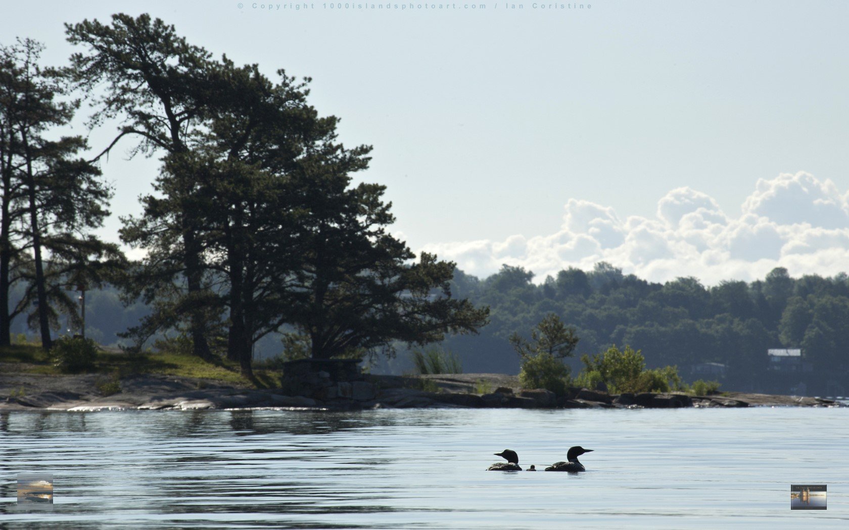
When the last wallpaper image was posted in the spring, I left you with a particularly challenging scene to identify as it could be so many places on the River. As it happens, it is a place that is very special to me, all the more so because I was just forced to leave it for the season. When the island transitions from delightful to difficult I get the message, particularly when difficult includes snow, which threatened on October 21st. It was time to go.

Not having expected any correct IDs, I was surprised to receive one from John Street, someone whose kindness has benefitted us all. John and Ann Street stepped up to the plate when my Internet camera gave up the ghost to offer their view of the River from Fernbank, west of Brockville. You can view it by clicking on "CAM" in the menu bar. John has my further gratitude and my dog Molly’s for coming to the rescue at another critical moment, years ago. I’ll let John explain:
"Your latest mystery wallpaper, which my sister and I both mis-identified, is still keeping me awake at night. Since my first guess on your latest wallpaper was way wrong (islands near our cottage in the Brockville Narrows), I just wondered if you might have tried to bamboozle your many fans by choosing a shot near YOUR cottage on Raleigh Island, just off the mouth of Jones Creek.
I checked NOAA river chart (#14771 at the very useful web site http://ocsdata.ncd.noaa.gov/OnLineViewer/GreatLakesViewerTable.htm ) and the lineup of islands looked about right: Looking downriver, Princess is in the foreground, then your home base of Raleigh Island, then Savage Island in the distance. Of course, a diligent search might turn up any number of other rocky points along the river that also might have been reasonable guesses.
Though I had boated from our place to Jones Creek many times, I wasn't really aware that there was a Raleigh Island until one day several years ago when I was driving home from our cottage to Honeoye, N.Y. along the St. Lawrence River Parkway (much more scenic than Highway 401). I had just passed Jones Creek when I saw a fellow up ahead trudging along the road shoulder carrying something on his back. As I got closer, the man started waving rather frantically for me to stop. It was then that I saw that the object he was carrying was a large red dog, draped across his shoulders and the back of his neck.
I pulled over, and he came to the car window. Obviously distraught, he explained that he'd been walking his dog in a nearby park and the dog had run into the road and been hit by a car. He asked if I could drive him back up the road a little way to near where he lived so he could get the dog to a vet. The poor dog, a large Irish setter, was very much alive but looked the worse for wear, with some cuts and blood on her face and who knew what other injuries.
Just back past Jones Creek, the man directed me down a driveway to near the river's edge. He said he needed to take a boat across to his island to get his car keys, and asked me if I could stay with the dog (he said her name was Molly) until he got back with the keys.
It certainly was the least I could do. I sat down near Molly, and she just lay down on the ground. She seemed OK, but I remember fervently hoping that she wouldn't die before the man got back. Shortly, the man returned, thanked me, and gently hustled Molly into his car for the trip to the vet. Just before driving off, he handed me a little book full of gorgeous photos of the Thousand Islands.
It was then that I finally figured out who he was -- the creator of that book. I told Ian that we already had a copy, and that we thought it was delightful. "Well, now you have two," he said.
I learned later that Molly had indeed survived her ordeal, and in fact was back enjoying life on Raleigh Island and keeping Ian company. Since then, Ian and I have kept in touch with occasional visits, and e-mails comparing our various travails trying to keep our little internet cameras transmitting live pictures from our river homes throughout the year. These things can be cantankerous, and when Ian's untended island camera failed he was able to figure a way to substitute our camera's pictures on his web site."
John Street
Honeoye, NY
A sincere thank you John, not just for your answer (which has earned you a set of TI prints), but for being the only person of several to stop on that most unhappy morning. The first few cars totally ignored me, whizzing right on by despite my best efforts to get them to stop so I could get her to the vet.
Let’s see if anyone can come up with a location for another toughie and if you can, please be good enough to share stories or lore relevant to the area.
Enjoy!
Ian Coristine
Download wide-angle version
Comments
I can't place the exact setting (it could be one of millions), but I sure can place the exact experience. It is one I have had many times before, on those mystical foggy mornings when no one in their right mind heads out in a boat (never mind what that says about me). I LOVE those kinds of tranquil days when only us loons are out there on the River. There is something magical about kayaking along the shoreline when the mist is thick and the water is dead calm. There is a special peace and beauty that can't be experienced at any other time. The stillness can make one feel like they are the only human being in the Universe, alone and communing with nature. One can sneak up on wildlife that would never be spotted on bright, sunny days. I have inadvertently paddled right up to blue herons, loons, muskrats, a wide variety of ducks, and even a beaver or two (who usually end up spoiling the moment with a loud slap of their tails on the water). Mind you, I am not authorizing anyone to go out and paddle in the fog, but if they do (don't forget your life jacket, whistle, and flares), they will look at a picture like this one and be able to say they've been there, too. Patty MondoreJamesville, NY
Patty Mondore posted on: Tuesday, November 04, 2008
Is it the head of Picton Island? Chuck and Sue Baum
Chuck and Sue Baum posted on: Tuesday, November 04, 2008
Chippewa point looking upriver? John Hart
John Hart posted on: Tuesday, November 04, 2008
The scene is could be any Island on the River. From my first look I think of Stovin Island in the Brockville Narrows. As a child growing up in Oak Point, our gang spent many a lazy summer afternoon jumping from the cliffs and tower into the Seaway. There is no greater thrill then a 25-30 foot jump into the icy cool water as a Salty steams by within fifty feet of the cliffs. Lunch always consisted of a cold Canadian brew with a bag of Don's fish and chips at our side. My favorite story of the narrows was a trip with five young women headed for a bit of cliff jumping. As we entered the narrows a Navy Ship was approaching from the north. The deck was loaded with sailors on their way to Clayton and the Bay for some R &R. The five of us welcomed the sailors to our little corner of the world with a wave. As we passed the ship and heads turned, the five bikinis clad girls stood up and "mooned" the boys. We could hear the cheers above the boat engine. Imagine the surprise on their faces when the five A-Bay waitresses served food and drink to the boys that evening and admitted our dirty little deed. The shore line in the picture may not be of Stovin looking up river, but the photo brings all my memories of the Island back. I still enjoy the Island today, jumping off the cliffs every summer with my teenage daughters. Thanks for the wonderful photos, they bring me great joy every month.Karen Buck AndrewsAustin, TX
Karen Buck Andrews posted on: Tuesday, November 04, 2008
I think this is a shot looking south (basically) along the southwest shore of Hay Island. Stephen P. Friot United States District Judge
Stephen P. Friot posted on: Tuesday, November 04, 2008
Not sure (of the angle) but new picture looks like a "fishy" spot near shore that we have tried several times, without success. If I am right, the point in background is the upstream Northern arm of Picton Island. The view is from the bay of an adjacent island, looking across the channel that runs through Swiftwater Point.Ronald Lundquist.
Ronald Lundquist. posted on: Tuesday, November 04, 2008
I think this photo is the back of Arcadia Island looking west toward Summerland and Ina Islands!Can't wait to get back to the river!Julie ChavoustieLake Placid, NY
Julie Chavoustie posted on: Tuesday, November 04, 2008
This looks an awful lot like my part of the River, a view you might easily miss unless you have access to canoe, kayak, paddle boat, sunfish or have decided you might wish to swim around the island! We refer to this piece of landscape as “The Bass Hole” – it appears to have been formed glacially; it is a perfect round, quite deep, and many a fisherman has cast a rod here in search of the elusive bass. It makes the most amazing sucking sound (thwuck plunk) as waves crash against the granite formation.�Following the shore line around to the front is another bay in which all the island grandchildren took much delight – Ladybug Bay - where toy boats were launched, snorkels and fins tested, and all manner of living things discovered –providing many hours of entertainment for parents and grandparents as well!�Intergenerational island living is an incredible gift, many thanks for the opportunity to revisit those wonderful memories.(Might it be of Huckleberry Island (Admiralty Group), looking towards Little Huckleberry?)Tricia Tague
Tricia Tague posted on: Tuesday, November 04, 2008
I feel hesitant to write you, yet I will feel worse if I am right and do not write. This scene looks to me to be taken along the shore of Bluff Island,just before the "turn" into The Boateak. If by any chance I am remembering correctly, the island in the distance would be Maple.I have been going to The Boateak off and on for years, to see what is there and to get cards or mementos. Usually I stop in on my way back from Clayton to Stave Island, in Canadian waters, across Eel Bay, which would also be to the left, or North, of this shot. I have lived on Stave since the late 50's, first in a tent, with a Coleman Stove and a biffy hole, and then, beginning in the early 70's, in a cabin with an outhouse. With four sons it felt like the cabin had become a necessity. When the sons grew up and wanted to invite young women to the island, I put on an addition, with running water and indoor facilities. I even have a washer and dryer. Still feels like a total luxury.Oh, I could go on and on. If you want more, just let me know. If this is not Bluff, I will not suffer total mortification, not to worry. And thank you for what you send out. I am always grateful. Sincerely, Elizabeth Kincaid-Ehlers
Elizabeth Kincaid-Ehlers posted on: Tuesday, November 04, 2008
I think May’s photo is of Leek Island (Thwartway) looking out from Marguerite Channel. My husband’s family lives next door on Juniper Island. His family fell in love with the river back in the early 1900’s while visiting their friends, the Kip family, on Leek Island. The Kips had a working farm with at least 100 acres of pasture, farm house, etc. During World War I Leek was used as a Red Cross camp. The family gave Leek to the Canadian Gov’t and is now a public park island and was renamed Thwartway. Leek beach is a very popular spot in the summer. Just found this link with Leek Red Cross camp info including photos.collectionresurrection.blogspot.com/2007_03_01_archive.htmlAbby RandStone Bridge Farm Bed & Breakfastwww.sbfbb.com
posted on: Tuesday, November 04, 2008
Ian,I'm not convinced I'm correct with the first photo, but my guess is the point pictured is the tip of Cleopatra Island. The second photo (with the loons) might be between Deer Island and Welsley Island, off the tip of Fairyland Island. (I think the island might be called Pike Island.) The land in the background is Welsley at Mary Island State Park.
Rich Calabrese, Jr. Castle Rest Island posted on: Tuesday, November 04, 2008
I don't have a clue where the photo was taken, but I'm very glad that Molly is OK!!! The first few paragraphs....I wasn't sure what the outcome of the dog would be, and was so happy that she survived!!Geneva, NY
Chandani Diaz posted on: Tuesday, November 04, 2008
Seems like the west end of Leek (Thwartway) looking south to Grindstone. I was born in Ivy Lea (have the passport to prove it) in 1944 and spent a great deal of my adult life aboard several cruising sailboats idling life away amoung the islands. Spent many hours picking my way through the shoals (forty acres) at idle with a bow lookout approaching the beach at Leek from other than the straight in approach. There used to be the remenants of a diviing board anchored to these rocks used by those recovering at the hospital (that is of course if this is the place - so much looks alike!)
Ken Truesdell posted on: Saturday, March 26, 2011
This looks like some place I ought to be.....not sure where it is but it brings a calm to an otherwise hectic day. Thanks so much for sharing!
Sue Sampier posted on: Saturday, March 26, 2011
Hi Ian, Love your work & very thankful that I discovered your site. Would this picture be off of the east end of Hill Island with Club Island in the background? I've watched a set of loons off my porch this summer & noticed a wee one with them one time or two. I love their call! Looking forward to April.....We closed our cottage October 15th & we miss it already. We are planning a trip up over New Years, staying at the Gan Inn & walking to the cottage from the Hill Island Tower. Last year there was a foot & a half of snow.... making it a LONG walk, hopefully it won't be quite as brutal this year! Mark & Brenda Bethlehem, Penna.
Mark Bond posted on: Saturday, March 26, 2011
I don't have a clue, could be so many. I look at your webcam several times a day to see the weather. I have a place on Dingman Pt. Road and can see Deer Island and thru the islands to Rockport. Been going to A Bay since I was 10. Now the kids and grandchildren go. It's only been a month since I closed and I miss it already. Your photos are beautiful. Thanks so much. Joyce Davenport, Beach Haven, PA
joyce davenport posted on: Saturday, March 26, 2011
The shore line in the background looks like the South East end of artists hide away.I have to confess canoeing out to your island with my wife to enjoy a river sun set.Those two Adirondack chairs are better then any $23.00 theater seat with the built in cup holder. As it was her first time in a canoe, being from the prairies, she still remembers it fondly. Ian, it is still a pleasure to pick up my copy of your book to remind me of my home away from home.I sure do miss the river out here in Alberta.
Chris, posted on: Saturday, March 26, 2011